Devpost
Participate in our public hackathons
Devpost for Teams
Access your company's private hackathons
Grow your developer ecosystem and promote your platform
Drive innovation, collaboration, and retention within your organization
By use case
Blog
Insights into hackathon planning and participation
Customer stories
Inspiration from peers and other industry leaders
Planning guides
Best practices for planning online and in-person hackathons
Webinars & events
Upcoming events and on-demand recordings
Help desk
Common questions and support documentation
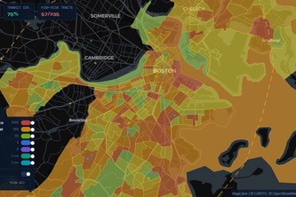
Mapping Boston's food system gaps to guide equitable action.
Boston lacks a clear view of how food moves from farms to neighborhoods. We’re building an interactive foodshed map that unifies scattered data to reveal gaps and support food equity.
Noesis is an AI sense-making tool that surfaces student thoughts from notes and nonverbal cues, promoting equity of voice, engagement, and teacher responsiveness.
Transparency is the first step to justice.
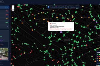
Automated Sidewalk Accessibility Validation for Inclusive Cities.
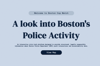
Police Interaction
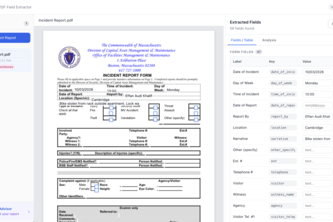
AI that transforms your legal reports into structured documents, auto-fills forms, and surfaces insights to help you navigate complex real-world processes.
A Boston surplus-food marketplace. Businesses list surplus at a set price and can donate a share to nearby food banks; buyers reserve and pick up. Less waste, more meals.
Analyzing Big Belly smart waste data at BU to optimize trash collection routes. The project uses data analysis to help BU reduce unnecessary pickups & build a greener campus.
Breathe smarter. Move safer. Live healthier.
Easy visualizations to locate hotspots of misconduct
This is a virtual tool to mitigate confusion during lectures and enhance peer collaboration.
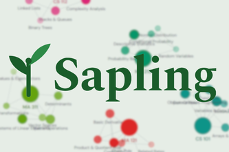
Sapling is an AI teaching platform that builds a live knowledge graph in real time as you learn. Watch your understanding grow, take adaptive quizzes, and find study partners through shared graphs.
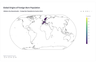
Investigating Gateway City Data in collaboration with GBH news
A spin on the Pax Romana... Pax Jamaica is a data-driven mapping project that identifies traffic and accessibility chokeholds and pavement distress in Jamaica Plain.
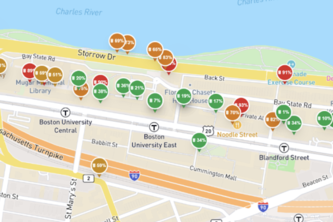
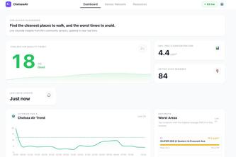
Our goal is to support the mission of GreenRoots by empowering Chelsea residents with tools to protect their health while promoting long-term environmental awareness and collective action.
Police interactions heavily impact Boston youth but the patterns remain hidden. We combine an AI rights chatbot with a district-level data map to reveal these encounters and reinforce accountability.
Tired of rushed, disconnected group projects? GroupPilot is an AI chatbot that builds collaboration through reflection, strengths based roles, and clear communication so teams do better work together.
A dual-AI Boston police-encounter game for minors that builds legal “muscle memory” and generates parent Preparedness Reports using performance analytics to pinpoint gaps and improve safety.
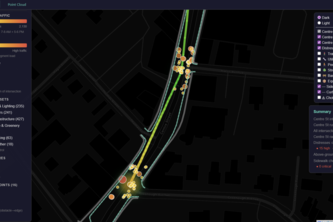
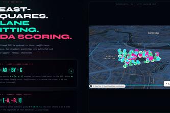
Automated LiDAR and ADA sidewalk compliance detection, 32k+ pavement hazards across Brookline, MA using point cloud plane-fitting to protect those who depend on accessible public infrastructure.
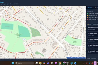
StreetSafe Equity Lens combines Cyvl condition data with Census demographics to rank roads by urgency and community impact helping cities prioritize repairs where failure causes the greatest harm.
Our project maps food banks and food resources in Greater Boston, helping people find nearby help and communities to see where food are supported using public and realtime data.
AI-driven civic intelligence for smarter, faster urban resolution.
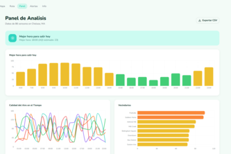
ChelseaAir: Real‑time air quality you can act on.
1 – 24 of 26